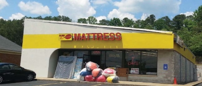
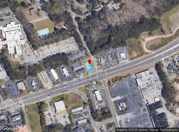
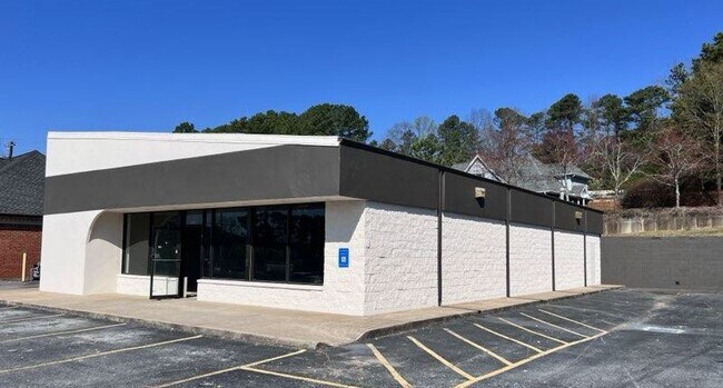
Property Record
2671 Main St W, Snellville, GA 30078
NEARBY LISTINGS FOR SALE OR LEASE
Property Detail
2671 Main St W
Atlanta-Sandy Springs-Roswell, GA
Hwy 78
5-026-238
US HWY 78
Storebuilding
Gwinnett
X
Georgia
13135C0128F
26
2025
0.38 AC
2025
Lilburn/Snellville
050763
Atlanta
3,164 SF
DEMOGRAPHICS near 2671 Main St W
1 Mile
3 Mile
5 Mile
2024 Total Population
6,463
65,881
179,894
2029 Population
6,791
68,910
187,923
Pop Growth 2024-2029
+ 5.08%
+ 4.60%
+ 4.46%
Average Age
39
39
38
2024 Total Households
2,228
21,477
57,670
HH Growth 2024-2029
+ 5.16%
+ 4.69%
+ 4.54%
Median Household Inc
$71,033
$85,215
$91,078
Avg Household Size
2.80
3.00
3.10
2024 Avg HH Vehicles
2.00
2.00
2.00
Median Home Value
$259,813
$287,053
$299,290
Median Year Built
1986
1988
1991
Nearby Places
Map Layers
Map Styles
 Street
 Aerial
- Restaurants
- Banks
- Shops
- Fitness
- Groceries
PUBLIC TRANSPORTATION
AIRPORT
Hartsfield - Jackson Atlanta International
DRIVE
WALK
Distance
Hartsfield - Jackson Atlanta International
48 min
32.3 mi
SALE & LEASE HISTORY
LISTING DATE
SALE/LEASE

Oct 20, 2022
For Lease
Jul 08, 2023
For Lease
Dec 08, 2023
For Lease
Dec 05, 2022
For Sale
Nearby Properties
Address
Land Use
TOTAL SIZE
Lot Size
Zoning
Address
Land Use
TOTAL SIZE
Lot Size
Zoning
362,674 SF
43.59 AC
CI
Address
Land Use
TOTAL SIZE
Lot Size
Zoning
469,566 SF
24.30 AC
RS180
Address
Land Use
TOTAL SIZE
Lot Size
Zoning
319,290 SF
2.05 AC
TC-MU
Address
Land Use
TOTAL SIZE
Lot Size
Zoning
245,208 SF
15.37 AC
RO
Address
Land Use
TOTAL SIZE
Lot Size
Zoning
278,756 SF
27.72 AC
RM
Address
Land Use
TOTAL SIZE
Lot Size
Zoning
274,964 SF
27.82 AC
BG
Address
Land Use
TOTAL SIZE
Lot Size
Zoning
230,417 SF
24.09 AC
BG
Address
Land Use
TOTAL SIZE
Lot Size
Zoning
214,082 SF
18.56 AC
BG
Address
Land Use
TOTAL SIZE
Lot Size
Zoning
283,953 SF
20.56 AC
RS30
Address
Land Use
TOTAL SIZE
Lot Size
Zoning
125,097 SF
1.01 AC
CI
Address
Land Use
TOTAL SIZE
Lot Size
Zoning
357,243 SF
59.63 AC
R100
Address
Land Use
TOTAL SIZE
Lot Size
Zoning
113,100 SF
11.39 AC
C2
Address
Land Use
TOTAL SIZE
Lot Size
Zoning
196,333 SF
23.27 AC
RS180
Address
Land Use
TOTAL SIZE
Lot Size
Zoning
139,448 SF
15.97 AC
RM
Address
Land Use
TOTAL SIZE
Lot Size
Zoning
202,864 SF
1.35 AC
TC-MU
Address
Land Use
TOTAL SIZE
Lot Size
Zoning
131,121 SF
12.99 AC
BG
Address
Land Use
TOTAL SIZE
Lot Size
Zoning
218,973 SF
21.04 AC
BG
Address
Land Use
TOTAL SIZE
Lot Size
Zoning
79,339 SF
38.25 AC
RS180
Address
Land Use
TOTAL SIZE
Lot Size
Zoning
120,113 SF
13 AC
BG
Address
Land Use
TOTAL SIZE
Lot Size
Zoning
99,280 SF
4.51 AC
C2
Address
Land Use
TOTAL SIZE
Lot Size
Zoning
108,123 SF
13.96 AC
R100
Address
Land Use
TOTAL SIZE
Lot Size
Zoning
122,201 SF
10.23 AC
BG
Address
Land Use
TOTAL SIZE
Lot Size
Zoning
100,913 SF
8.30 AC
HSB
Address
Land Use
TOTAL SIZE
Lot Size
Zoning
97,411 SF
8.47 AC
BG
Address
Land Use
TOTAL SIZE
Lot Size
Zoning
111,732 SF
9.71 AC
CI
Address
Land Use
TOTAL SIZE
Lot Size
Zoning
55,810 SF
8.28 AC
R100
Address
Land Use
TOTAL SIZE
Lot Size
Zoning
61,200 SF
0.59 AC
CI
Address
Land Use
TOTAL SIZE
Lot Size
Zoning
66,544 SF
6.70 AC
BG
Address
Land Use
TOTAL SIZE
Lot Size
Zoning
103,660 SF
9.58 AC
BG
Address
Land Use
TOTAL SIZE
Lot Size
Zoning
103,821 SF
10.80 AC
M1
The World's #1 Commercial Real Estate Marketplace
Connect with us
© 2026 CoStar Group
The information above has been obtained from sources believed reliable. While we do not doubt its accuracy we have not verified it and make no guarantee, warranty or representation about it. It is your responsibility to independently confirm its accuracy and completeness. Any projections, opinions, assumptions, or estimates used are for example only and do not represent the current or future performance of the property. The value of this transaction to you depends on tax and other factors which should be evaluated by your tax, financial, and legal advisors. You and your advisors should conduct a careful, independent investigation of the property to determine to your satisfaction the suitability of the property for your needs.